

I had seen the Grand Canyon from the rim many times in the past. But I had never made it down to the Colorado River, which meanders on the canyon floor. If I wanted to touch the waters of the river at least once in my life, now, in my late thirties, would be the high time to do it.
Instead of writing a philosophical treatise on why people want to descent into the Grand Canyon, I will just use the famous “because it’s there”—the daring phrase uttered by climber George Mallory when a reporter asked him why he wanted to scale Mt. Everest.
Maybe one lofty sentence would be in order. Grand Canyon, indeed, happens to be a breathtaking wonder, with a special appeal to us Europeans. Being used to only fields & forests, we never stop marveling at the enormous crack in the Arizona desert, which exposes rocks of all imaginable colors.
The hike I planned from the South Rim to the bottom, and back up, involved 17 miles (27 km) of walking and 4,600 feet (1400 m) of elevation difference.
Plans work out, sometimes

I arrived in Williams, Arizona, one September evening. This small town, with a flair of non-touristy, Western authenticity, lies 60 miles (95 km) away from the South Rim of the canyon. The next day would be the D-day.
Given that I opted for walking down & up without staying overnight (my camping days are long over), the itinerary turned out to be straightforward. To safely return to the rim around two o’clock in the afternoon—a golden rule of Grand Canyon hiking—I had to begin walking at five in the morning.

Early in the morning of the D-day, I therefore found myself in a taxi, speeding from Williams to the South Kaibab Trailhead at the South Rim. The road, leading through the dark, empty Arizona, was empty of cars itself.
The taxi driver filled the one-hour journey with an initially friendly conversation, which, nevertheless, gradually turned into a conspiracy monologue on how the government hides facts about aliens from the outer space. As we were approaching our destination, we entered a forest. At that instant, my world contained only silhouettes of trees, the starry black sky, and the space-obsessed taxi driver that would not stop talking. In the end, I was the one who wished to be on another planet.

No light in the darkness
The first glitch in my planning came early on as we spotted a barrier on the road, still some distance before the trailhead. Apparently only buses coming from the nearby Grand Canyon Village can continue past that point. Well, I had no choice but to pay the driver and get out of the car.
Standing alone in the middle of the dark forest, I noticed the second glitch in my planning. I guess it would have required a Himalaya-style preparation, which I was clearly incapable of, to figure out that it might be still dark at five o’clock in the morning and to bring a flashlight.
Ashamed of my transformation from an industrious small-town boy to a metropolitan glamper, I took out the cellphone from my backpack and turned the lamp on. Thus equipped, I walked about a mile along the road to the edge of the canyon, where the trail begins its descent.

The only way to hike a canyon…
I decided to hike down along the South Kaibab Trail because it is the shortest one. But naturally also the steepest one (“trail in a hurry to get to the river”). To walk back up to the South Rim, however, I planned to use the more traveled, slightly longer, but also slightly gentler, Bright Angel Trail.
The intricacies of canyon hiking were known to me. I had to get down as quickly as possible, in order to leave enough time for the arduous task of transporting my body back up. Unlike in the mountains, where I could turn around (almost) anytime, there is no safe escape from the canyon. The only option is a successful ascent.
While I was getting ready to walk down, a bus from Grand Canyon Village arrived at the trailhead and unloaded a crowd of hikers with large backpacks and walking poles. I became exercised. Instead of connecting with the nature, I would have to elbow my way ahead on the trail and listen to loud gossiping. My anger turned out to be fortunately premature—a large portion of the group would walk together only later, after receiving some lengthy prep talk.
As I set off, it was still dark. This time, however, the trail was illuminated for me by a couple wearing headlamps. They were the only ones that I happily let walk in front of me.
Even the sun is too small for the Grand Canyon
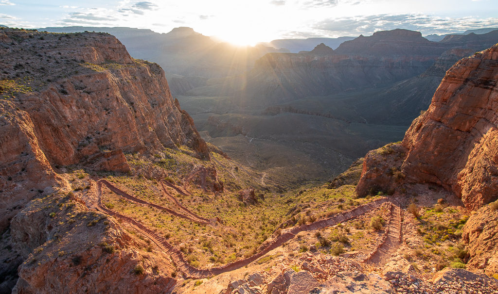
Originally, I was going to say that the first part of the trail followed steep switchbacks down, but actually, the entire trail was a never-ending series of steep switchbacks.

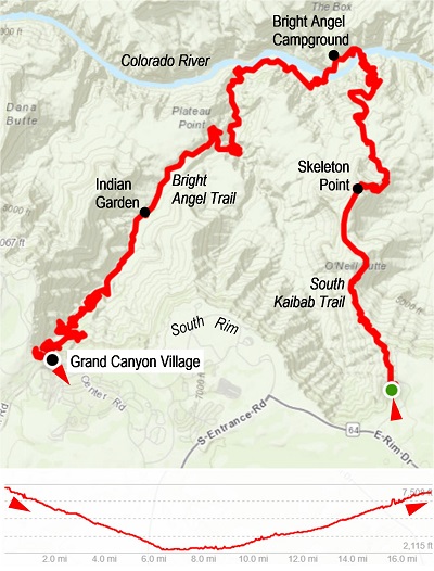
The most magical moment of the whole day came at six o’clock. I was concentrating on not tripping on the trail when the rays of sun began to appear from behind the horizon. In a few minutes, the sun itself made an entrance. The wide strip of rocks right below the rim gained more and more vivid shades of reddish and orange colors, which the reader knows from all the vintage photographs.
What struck me most about that moment was the smallness of the morning sun. The tiny shining ball had hard time pulling itself up above the cliffs in the east, and even when it did, it could not compete with the grandness of the Grand Canyon.
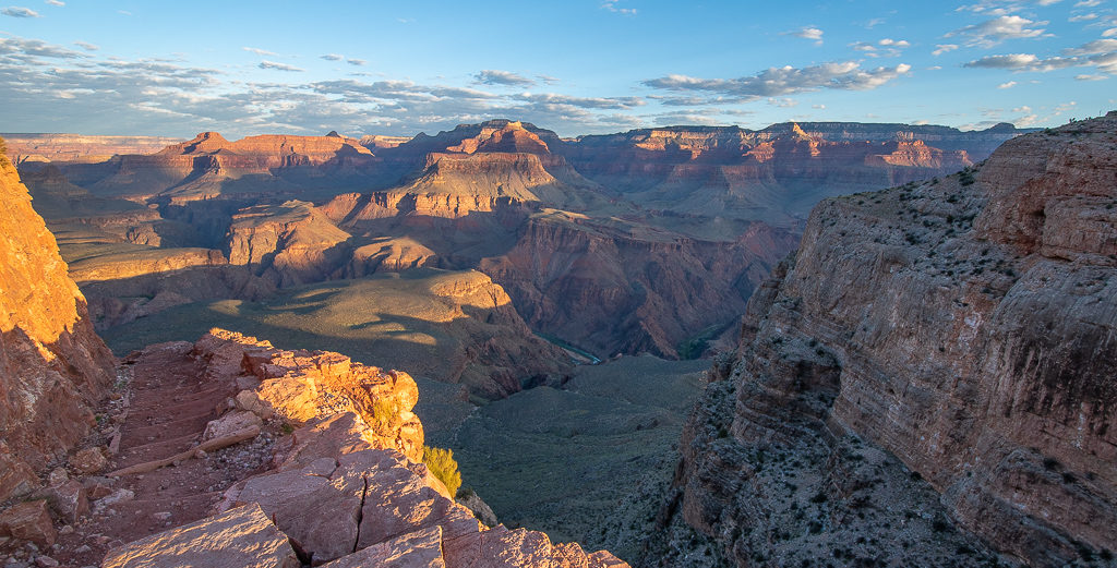
That should not have surprised me given the dimensions of the canyon: from the South Rim to the North Rim, the canyon is 10 miles (16 km) wide, and the waters of the Colorado River flow 4,600 feet (1400 m) below the rim level. Incredibly, the river spends full 277 miles (446 km) cutting through the canyon.
Survival guide’s back
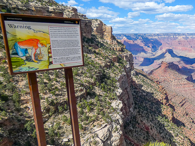
Despite appearing small in the morning, the sun was, of course, about to gain strength throughout the day. In its climate, the Grand Canyon resembles a mix of a desert and high-elevation mountains. The South Rim, around Grand Canyon Village, lies at the elevation of about 7,000 feet (2100 m), but the slopes of the canyon get so much sunshine that the heat poses a grave danger to hikers.
In fact, all trails in the Grand Canyon are marked by a poster, which depicts an exhausted man with sunburned back, kneeling down, and vomiting. In 2017, for instance, emergency services had to rescue 290 people from the canyon. Most of these incidents were caused by fatigue, insufficient preparation, or a fall. Sure, millions of visitors come to the Grand Canyon every year, but the number of rescue missions should make everyone take the preparations as seriously as those for Mt. Everest.
This was the part of the trip where I could not afford a glitch in planning—I had to return around two o’clock to avoid the worst heat, and I carried seven liters of water on my back. The safest assumption was that I would not pass by any source of potable water.
The choice of season is important as well. September represents one of the more reasonable months to go because the scorching heat is a bit less scorching than in the summer, and yet, September does not bring the cold nights coupled with snow, which can very well arrive with October.
Take me to the river
I kept walking down all the way to the cheerfully named Skeleton Point. From there, I could see the river down below for the first time (you can spot the river from certain points along the rim, but not from the South Kaibab Trailhead).

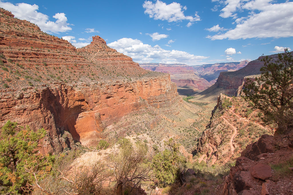
After many more switchbacks , I passed by several campers who were just leaving their tents, and then I noticed I entered a new landscape—a grassy plateau. But that ended shortly, and the trailed continued along cliffs of brown rocks.
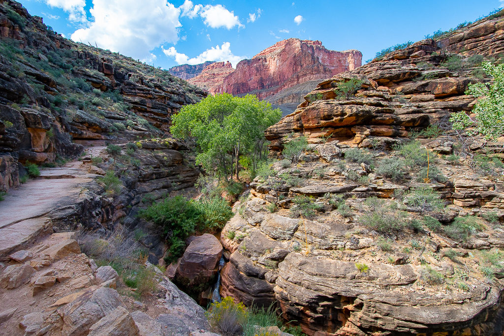
Soon enough, the first person overtook me—a runner, for whom my once-in-a-lifetime hike was apparently just a morning jog. And right before the river, I encountered the first crowd—people who stayed overnight in the campground at the floor, and now were being carried up by mules. I had to yield to this caravan, but it did not slow me down too much, fortunately.
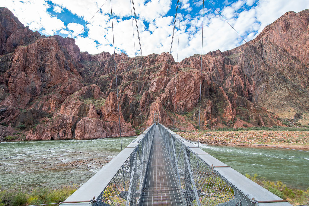
There I was, finally, on the bridge crossing the Colorado River. Its stream looked somewhat—or rather substantially—mightier than what I had seen from above. Behind the bridge, I found a place on the bank and tested the water temperature with my hand. At that moment, I basked in the glory of having finished the first part of the hike, which meant exactly nothing, however, because the more difficult part was still coming up. It was almost eight o’clock, and after a quick snack, I began walking along the river.
Stones and rocks
The rocks around me were created two billion years ago, yet geologists call the Grand Canyon young. The reason for this flattery is that the river carved out the canyon only six million years ago, with the help of a few tributaries.

Stony bases of the ancient structures that I passed show that Native peoples used to live at the bottom of the canyon. For them, of course, hiking down & up was a necessity, not a “because it’s there”-vanity.
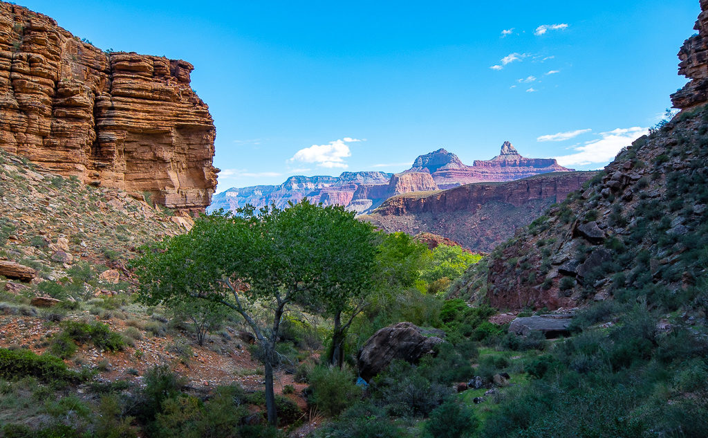
Near the Bright Angel Campground, the South Kaibab Trail turns into the Bright Angel Trail, which crosses the river back to the south side, and before long, it begins its climb back to the rim. The landscape around looked deceiving. I could not see the top of the canyon as I was leaving the river behind. The rocky formations resembled some scenic-yet-unremarkable highland, and nothing indicated I was on the floor of a gigantic canyon.


The ascent seemed manageable enough all the way up to the oasis called Indian Garden. Afterward, the trail became steeper and steeper. The sun began to shine sharply, and the body showed the first signs of severe tiredness. I stopped for a moment to take in the views of the canyon, absorbing the shades of red, this time under the most intense daylight. A flute player practicing nearby turned it into another magical moment of the day.
Up, up, up
Two more miles to go, and the canyon was already humbling me. Whenever I thought I got close to the top, a new layer of rocks emerged above me. Yes, spectacular, but also tens of feet high. With already fifteen miles in my legs, every step became a challenge. The sun was shining much more sharply, but mercifully, the occasional September clouds shielded me from the rays. I drank water every few seconds and finally realized that the exhausted, vomiting poster guy was not a joke.


The first flip-flop tourists began to appear—the leisure tourists, who were taking a brief stroll down from the rim and wore flip-flops for the occasion. I knew their happy faces would fade with the first step on the way back up.

After the most challenging part of the hike, I finally passed the famous tunnel on the trail, and in a few minutes, stood on the rim at Grand Canyon Village. All sweaty. After nine hours and twenty minutes, slightly past two o’clock. Seeing the canyon in front of me brought that feeling of reward even though I could not see the river down below anymore. My legs were there to helpfully remind me from what kind of depth had I just emerged.
Soon enough, I was disturbed by a busload of visitors who, for whatever reason, had to exude animal-like screams with every group picture they took. Too tired to get upset, I just looked at the canyon one last time. “Because it’s there,” I said to myself.

Addendum
If anyone wants to quickly recover from the canyon experience, they can immediately try to scale the humongous Humphreys Peak (12,637 feet or 3852 m), the highest mountain of Arizona. It is conveniently visible from the road back to Williams.
If you go…
- Grand Canyon is designated as a National Park (founded in 1919). You must therefore pay the entrance fee and obey the Park’s rules.
- There are three principal trails leading to the bottom of the Grand Canyon. Two of the them, the South Kaibab and Bright Angel Trails, descend from the South Rim, whereas the North Kaibab Trail goes down from the North Rim. All three trails meet on the floor, at the Colorado River, near the Bright Angel Campground.

- My hike, taking the South Kaibab Trail down and the Bright Angel Trail up, totaled 17 miles (27 km), with the elevation gain of 4,600 feet (1400 m). I needed 9 hours 20 minutes to complete it, including breaks. Some hikers choose the rim-to-rim hike (from the South to the North Rim, or vice versa), which totals 24 miles. To reach any trailhead to start your hike, you can use the shuttle buses operated by the National Park.
- Generally, the Park Service does NOT recommend hiking down & up the canyon within one day. Unless you are in a great physical shape and sufficiently prepared.
- It is possible to stay overnight at the bottom of the canyon, either in the Bright Angel Campground or in the Phantom Range Lodge. Make sure to book your place well in advance.
- To stay overnight near the Grand Canyon, you can choose either Grand Canyon Village on the National Park’s premises (potentially more expensive) or rent a place in one of the towns nearby, such as Flagstaff or Williams.
Other Grand Canyon activities
- Williams is a pleasant town, with remnants of the Western charm and several highly rated restaurants. I very much enjoyed South Rims Wine & Beer Garage.
- The Grand Canyon area offers more besides hiking:
- >>> a helicopter flight over the canyon. You can book a helicopter from the airport in Tusayan, a small settlement near the entrance to the National Park.
- >>> the Skywalk, which is a glass platform sticking above the canyon, at the western end of the National Park. While good for getting an adrenaline rush, get ready for potentially long lines of tourists and extra payment for taking pictures. The Skywalk lies several hours of drive from Grand Canyon Village, 50 miles (80 km) off the road to Las Vegas.